

Laser rangefinders time a light pulse to the target and back, while GPS rangefinders fix the golfer's position from satellite signals and read pre-mapped course distances. The important difference isn't the display, it's what the displayed distance refers to.
A golfer standing over an approach shot might see a pin reading on a laser and a different center-green number on a watch. Neither device necessarily needs replacing. Before choosing a club, the golfer needs to establish whether those numbers describe the same destination.
Table of Contents
- Start on the Shot
- Laser and GPS Rangefinders Compared
- How Laser Rangefinders Measure to the Flagstick
- How GPS Rangefinders Read the Course
- Accuracy Ratings and Features Worth Knowing
- Why a Precise Rangefinder Locks the Wrong Target
- Using Rangefinders on Real Shots and in Competition
- Choosing the Right Rangefinder for Your Game
Start on the Shot
Consider a hypothetical approach from around 150 yards out. The laser reads 148 yards to the flagstick, while the GPS watch shows 145 yards to the green's center. Both can be telling the truth because the flag isn't necessarily in the middle of the green.
A golf rangefinder turns light or satellite signals into a usable distance. Its job is measurement, not club selection, and that distinction matters when a golfer faces a tucked flag, a raised green, or trouble beyond the putting surface.
The starting question: Which point does this yardage describe?
The answer to “how do golf range finders work” becomes useful when the golfer follows the measurement from its origin to its destination. A laser's timing cycle explains how a reflection becomes a distance. A GPS position fix and course lookup explain why a watch can report a green that's hidden behind a hill.
Accuracy specifications describe the limits of those measurements, while features such as magnification and target confirmation affect how easily the golfer gets a usable result. The less obvious problem is target selection: an accurate instrument can still measure the wrong object.
A sound routine therefore starts before the club comes out of the bag. Identify the destination, confirm what the device measured, and compare that distance with a carry the golfer can realistically produce. That's enough to explain an apparent disagreement to a playing partner and choose the measurement method that fits the shot.
Laser and GPS Rangefinders Compared
A laser rangefinder measures the straight-line distance to the visible point selected through its optics. A GPS rangefinder locates the golfer and calculates distances to features stored in a course map.
Laser vs GPS rangefinders at a glance
| Aspect | Laser rangefinder | GPS rangefinder |
|---|---|---|
| How it measures | Times a light pulse to the target and back | Trilaterates position from satellite signals |
| What it reports | Straight-line distance to the point aimed at | Pre-mapped distances to greens, hazards and doglegs |
| Slope adjustment | Common; disable for tournament play | Available on some models |
| Blind shots | Needs line of sight to the target | Works without seeing the green |
| Best for | Pin hunting, bunkers, trees and visible layup points | Course management and front-center-back numbers |
Different signals, different reference points
For satellite positioning, the FAA's explanation of how GPS works describes timing signals that travel at 299,792,458 meters per second, a receiver generally using at least four satellites, and basic service providing approximately 7.0-meter accuracy 95% of the time. Those figures describe the positioning system, not a promise that every golf watch will show an identical distance.
The laser's reference point is whatever produces the selected reflection. The GPS device's reference points are the golfer's calculated position and the mapped destination. That's why an exact flag reading and a center-green reading shouldn't be treated as competing answers.
GPS positioning also changes with receiver quality, satellite geometry, atmospheric conditions and reflected signals. A fixed number on a screen doesn't mean the underlying position is perfectly fixed.
Choose the question before the instrument
A golfer looking at a bunker can use a laser to measure its visible lip. A golfer unable to see the green can still use GPS to inspect the mapped route and landing area. Hybrid devices combine those approaches rather than introducing a different measurement principle.
Slope adjustment is a separate layer. It turns elevation information into an estimated playing distance; it doesn't change the identity of the measured point. Golfers should distinguish the actual distance from any adjusted recommendation.
The same separation matters when selecting a launch monitor for driving-range practice: measuring a target and measuring a ball's flight answer different questions.
The practical takeaway is straightforward. Laser answers how far to that exact point. GPS answers how far to the mapped places on this hole.
How Laser Rangefinders Measure to the Flagstick
Shouting toward a cliff and timing the returning echo reveals how far away the cliff stands. A laser rangefinder applies the same round-trip idea using light instead of sound.
The process below follows the signal from the golfer's aim to the displayed yardage.
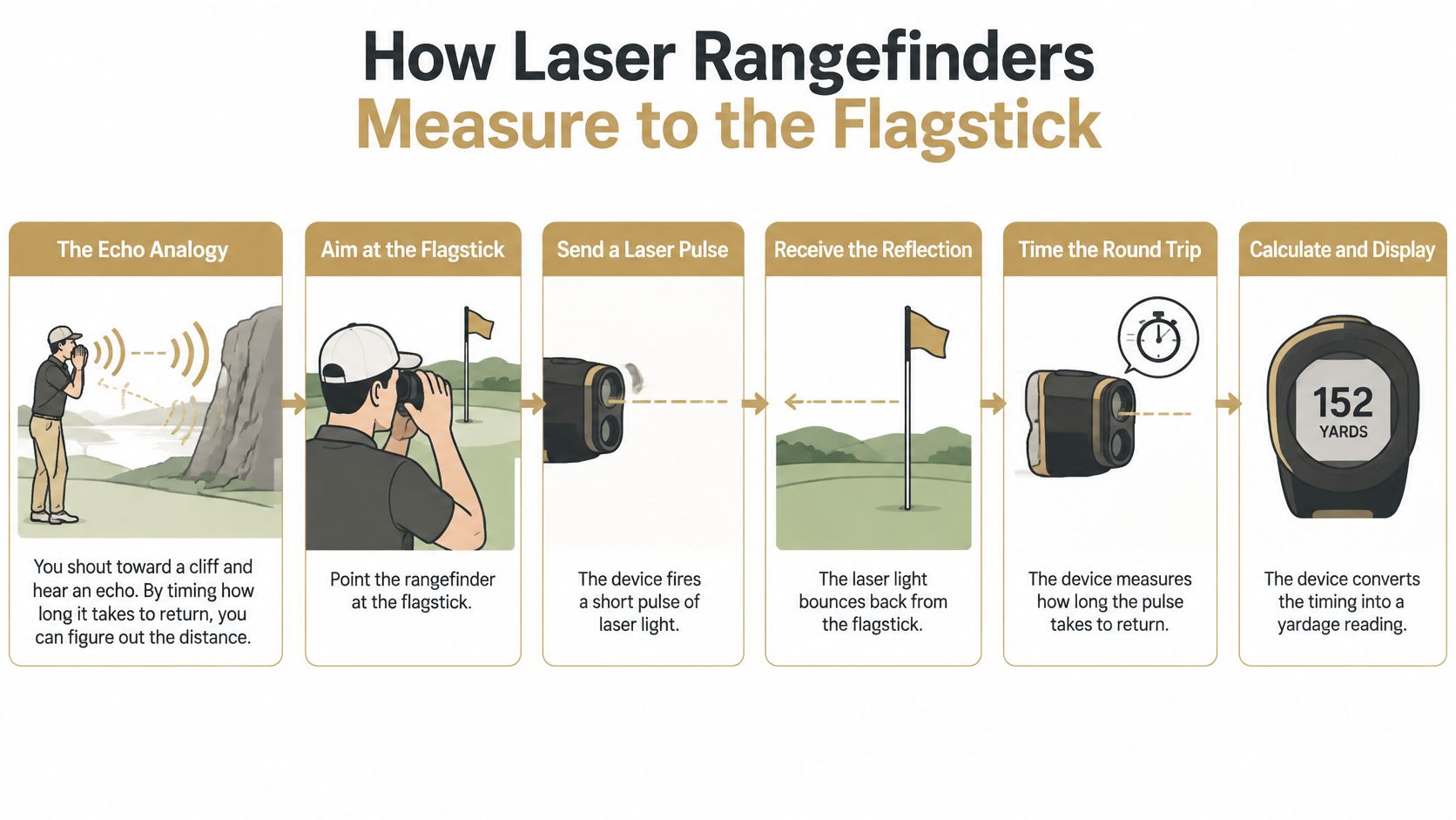
From aim to displayed distance
- Aim through the optics. The golfer brings the flagstick into view and places the aiming circle over it. A clear reticle matters because a blurred aiming reference makes precise placement harder.
- Send the pulse. Pressing the measurement button triggers the laser emitter. The golfer should follow the device's safety labeling rather than assume every model has the same laser classification.
- Receive reflected light. Light reaches the scene, and some reflects toward the receiver. The instrument needs a usable return, not merely an object somewhere inside the viewfinder.
- Measure the elapsed time. Internal electronics determine the interval between transmission and reception. A more distant target produces a longer round trip.
- Calculate the distance. The processor applies distance = elapsed time × speed of light ÷ two. The division removes the return journey, leaving the distance from the instrument to the target.
- Display the result. The yardage appears in the viewfinder. Some models add a vibration, often called jolt, or another target-confirmation signal.
Target modes need careful interpretation
First-target priority favors the closest usable object among overlapping returns. That's useful when a flagstick stands in front of trees, provided the golfer hasn't included a nearer branch or mound in the measurement.
Pinseeker-style modes help acquire a flag among surrounding objects. Second-target or distant-target modes may instead favor something behind foreground clutter; those names shouldn't be treated as interchangeable with flag-seeking behavior. The device manual determines what a particular setting selects.
Scan mode lets the golfer sweep across the scene and compare changing distances. It's especially useful for separating the pin from the objects surrounding it rather than accepting an isolated number.
The following demonstration provides another view of the measurement process.
A reflective flagstick prism sends a cleaner return toward the instrument, making acquisition easier. A broad tree or bunker face can also return a strong signal, but the golfer may not aim at exactly the same part each time. A defined aiming point supports repeatable readings.
How GPS Rangefinders Read the Course
On a par five, a GPS unit shows three green numbers: front, center and back. The flag sits behind a front bunker, so the center figure would leave the approach short, the back figure sets the club, and the front figure sets the carry. All three come from the course map. None is a laser measurement of the flag itself.
The receiver first works out where the golfer is. It uses ranges derived from satellite timing, a process properly called trilateration. “Triangulation” is the familiar name, though GPS measures time and distance rather than angles. Enough satellite ranges intersect at one location, and software matches that coordinate to mapped features.
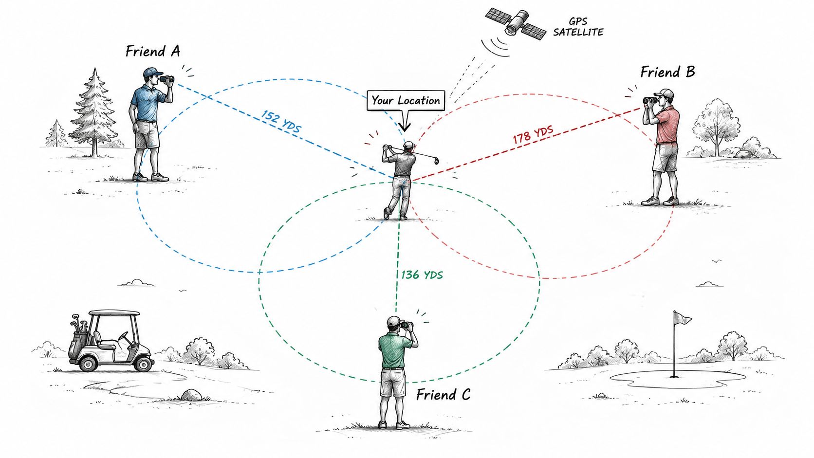
From satellite signals to course distances
- Listen for satellites. The receiver in a handheld unit, watch or phone collects signals from satellites above the horizon. It needs enough usable information to solve its position and account for receiver-clock error.
- Read position and time information. The signals provide information about satellite positions and when the signals were transmitted.
- Compare transmission and arrival. The receiver works out how long the signals took to arrive. Because the signals travel at a known speed, time can be converted into distance.
- Build satellite ranges. Each calculated range constrains where the receiver could be relative to that satellite.
- Solve the position. The receiver combines those constraints to calculate the golfer's coordinates.
- Look up the course. Software compares that position with mapped green boundaries, hazards and doglegs, then displays the relevant distances.
A good position still needs a good map
The satellite calculation does not locate today's flagstick by itself. A front-center-back display describes mapped green references, and an exact pin distance requires additional pin-location information. Mapping therefore matters alongside receiver performance. An outdated bunker outline, the wrong selected hole or an incorrectly positioned green reference can make a plausible display less useful for the shot.
A GPS center-green number describes a mapped destination. The flag may sit several paces from it.
Use a target-confidence routine before pulling a club. Read the three numbers, compare them with the visible green shape and any on-course marker, then confirm the selected hole. On the back-flag hole above, the back number sets the club and the front number sets the carry; the center figure gives context, not the pin. If the display and the landmark disagree, recheck the hole and the mapped reference before acting. For a visible flag, a laser reads the pin itself. GPS supplies the surrounding map, which lets the golfer choose a target with the whole green in view.
Accuracy Ratings and Features Worth Knowing
Laser distance accuracy and GPS positional accuracy describe different kinds of error. One concerns a measured target distance; the other concerns the receiver's calculated location before software calculates a distance to a mapped destination.
Neither specification guarantees flag identification. Treat the values below as shorthand for reading a specification, then verify the feature against the shot you play.
Panxis's technical explanation of rangefinder target errors describes nominal laser accuracy of about one yard and explains why real-world target selection can still go wrong. That distinction matters because the table's laser figure describes a clean, reflective target in testing.
What golf rangefinder specifications mean
| Specification | What it describes | Typical value |
|---|---|---|
| Laser distance accuracy | Error to a clean, reflective target in testing | About ±1 yard |
| GPS positional accuracy | Error in the receiver's calculated position | Typically several meters, depending on conditions |
| Optical magnification | Enlargement through the laser viewfinder | Model-specific; check the published specification |
| Maximum ranging distance | Farthest suitable target the laser can read | Target-dependent; check flag-ranging capability separately |
| Slope compensation | Elevation-adjusted playing distance | Common; must be disableable for competition |
Optics and reach solve different problems
Magnification improves aiming. The timing calculation remains the same. A larger flag image can make reticle placement easier, and the golfer still needs a comfortable view, readable display and steady hold.
Before buying, look through the device while wearing the glasses normally used on the course. Adjusting the eyepiece until the reticle is sharp tells more than a magnification label.
Maximum range describes a different target than reliable flag range. A broad, reflective object can be easier to measure than a thin flagstick, so the largest number on the packaging may describe a target unlike the one the golfer usually measures. Confirm flag-ranging capability separately.
Competition play requires a clear way to disable slope compensation. The golfer should know that control before the first round.
Features that earn their place
- Target feedback: A visible lock indicator, tone or vibration helps the golfer recognize an acquired reading without lowering the instrument.
- Scan controls: A simple hold-and-sweep operation makes comparison easier when the flag sits against a busy background.
- Weather protection: The stated protection rating should match the conditions in which the golfer plays.
- Power and storage: Battery type, charging access and secure magnet mounting affect whether the instrument remains usable through a round.
Target feedback and scan controls also support the target-confidence routine: identify the intended point, sweep across and beyond it, then confirm the number matches the flag rather than the background. A golfer who frequently loses the flag against trees should prioritize acquisition and comfortable optics. A golfer who mainly needs immediate green references should prioritize a clear course display and straightforward hole selection.
Choose features that solve the recurring shot. A feature earns its price when it fixes an actual problem during play.
Why a Precise Rangefinder Locks the Wrong Target
A tight accuracy rating can tempt a golfer to trust every displayed number. That confuses measurement precision with target selection.
A thin flagstick may return less light than the trees, bunker face or clubhouse behind it, allowing the device to settle on a background object. The Panxis technical explanation of rangefinder target errors describes background-lock errors of 20–30 yards despite nominal device accuracy of about one yard.
The instrument can measure that background accurately while giving the golfer the wrong yardage for the intended shot. Software filters and target modes help, but they don't remove the golfer's responsibility to confirm the destination.
The checklist below separates a precise reading from a trustworthy pin reading.
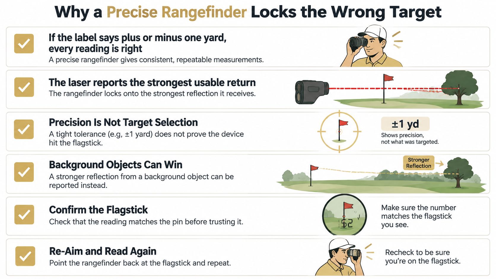
A target-confidence routine
- Identify the intended point before lifting the device. The golfer should distinguish the flagstick from its background and decide whether the desired measurement is the pin, bunker edge or another reference.
- Scan across the flag and beyond it. Watching the display change helps separate the nearer target from the farther background. A number that appears only when the reticle drifts toward trees deserves scrutiny.
- Wait for target feedback. A lock indicator or vibration supports confidence in acquisition, but it isn't independent proof that the selected object is the flagstick.
- Repeat from a slightly different position. A small sideways step can change the alignment between the pin and background. A meaningful disagreement calls for another look, not an average.
- Check against another reference. GPS green boundaries or a known course marker can reveal an implausible result, provided the golfer compares the correct destinations and allows for marker location.
- Use the reflective prism when present. A deliberate aim at the flagstick's reflector can improve acquisition rather than relying on a sweep across the surrounding scene.
Decide what to trust
Confidence comes from agreement: the visible target, repeat reading and course context should support the same decision.
GPS is a plausibility check, not an automatic referee. A flag near the back of a green should read longer than its center, so disagreement alone doesn't establish a fault.
The useful habit is to investigate unexplained differences before acting. That's the same discipline a golfer applies to a launch-monitor session: confirm the inputs and measurement conditions before drawing conclusions about the clubs.
Using Rangefinders on Real Shots and in Competition
A tee shot over a blind bunker: A laser can measure a visible lip or a tree beyond it, but neither necessarily represents the required carry. GPS can supply the mapped hazard relationship when the landing area is hidden.
An approach to a tiered green: GPS gives a useful center reference, while the laser supplies the visible pin distance. The golfer then decides whether the flag or a safer part of the putting surface is the right destination.
Match the measurement to the task
A layup hole: A laser measurement to a visible, reachable layup reference is more useful than an unrelated center-green number. The golfer should select the actual landing area rather than treat every course marker as the ideal target.
A long dogleg: GPS can show the distance to the elbow when the green is invisible. The decision is how far to advance while preserving an approach, not how far the hole extends in a straight line.
Those situations require different measurements, but club selection uses a consistent comparison:
- Laser point distance: The distance to the selected visible object.
- GPS mapped distance: The relationship between the golfer and a course feature or landing area.
- Launch-monitor carry: Evidence of how far the golfer's club sends the ball through the air.
The first sources describe the shot's demand; the last describes the golfer's delivery. They shouldn't be averaged into a single number.
For example, a hazard carry needs comparison with a dependable airborne distance, not a best-ever total that includes rollout. The same distinction matters when evaluating 4-hybrid distance against a landing area or obstacle.
Competition settings need a separate check
Under the USGA's guidance on distance-measuring devices, Rule 4.3 has permitted distance-measuring devices since January 1, 2019, unless the committee adopts a Local Rule prohibiting them; a first breach brings loss of hole in match play or a two-stroke penalty in stroke play, and a second breach during the same round brings disqualification.
Distance and direction information are permitted under that guidance, but not every form of electronic assistance is allowed. Golfers should check the competition's Local Rules and disable slope-adjusted assistance before play rather than assume a device's ordinary practice settings are legal.
Choosing the Right Rangefinder for Your Game
Laser-first suits visible, specific targets. Golfers who hunt pins or frequently measure trees, bunker edges and layup points should prioritize easy acquisition and clear optics, especially on tree-lined courses.
GPS-first suits route planning. Blind shots, open links-style layouts and frequent front-center-back decisions reward immediate mapped context without aiming. A hybrid device, or carrying both types, makes sense when neither task is occasional. Neither type removes the aiming work. It only changes when that work happens.
The next action is a controlled comparison against known targets and actual ball flight. A structured golf bag gap analysis separates a target-distance problem from a club-carry problem.
Dialed Golf's desktop app for macOS and Windows handles range and garage-simulator practice, with live pairing starting at Garmin R10 and opening sessions through CSV import from sources including FlightScope, SkyTrak and GSPro.
Before acting on any number, run the target-confidence check: pick the visible object, confirm the device returned that object, and match the yardage to a carry you can repeat under pressure. Where the two disagree, the shot decision belongs to the repeatable carry.